
Файл:Public Schools Historical Atlas - Europe 1135.jpg

Памер прагляду: 773 × 600 піксэлаў. Іншыя разрозьненьні: 309 × 240 піксэлаў | 619 × 480 піксэлаў | 990 × 768 піксэлаў | 1280 × 994 піксэлаў | 2234 × 1734 піксэлаў.
Арыгінальны файл (2234 × 1734 піксэлі, памер файла: 1013 кб, тып MIME: image/jpeg)
|
|
Гэты файл паходзіць зь Вікісховішча. Зьвесткі пра гэты файл зь яго старонкі апісаньня прыведзеныя ніжэй. Вікісховішча — сховішча вольных мэдыяфайлаў. Вы можаце дапамагчы. |
Апісаньне
_en.png)
.png)
.jpg)
Ліцэнзія
This media file is in the public domain in the United States. This applies to U.S. works where the copyright has expired, often because its first publication occurred prior to January 1, 1929, and if not then due to lack of notice or renewal. See this page for further explanation.
|
 | |
 |
This image might not be in the public domain outside of the United States; this especially applies in the countries and areas that do not apply the rule of the shorter term for US works, such as Canada, Mainland China (not Hong Kong or Macao), Germany, Mexico, and Switzerland. The creator and year of publication are essential information and must be provided. See Wikipedia:Public domain and Wikipedia:Copyrights for more details.
|
Гісторыя файла
Націсьніце на дату/час, каб паглядзець, як тады выглядаў файл.
| Дата і час | Мініятура | Памеры | Удзельнік | Камэнтар | |
|---|---|---|---|---|---|
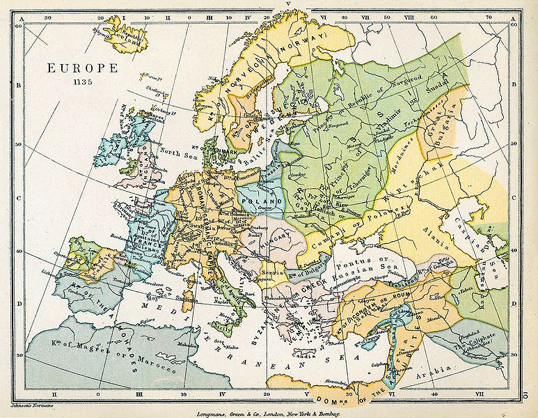
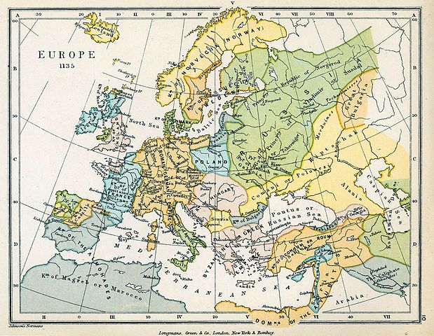
| цяперашняя | 21:26, 18 чэрвеня 2009 | | 2234 × 1734 (1013 кб) | Yarl | == {{int:filedesc}} == {{Information |Description={{en|Map of Europe in 1135.}} |Source= * ''The Public Schools Historical Atlas'' by Charles Colbeck. Longmans, Green; New York; London; Bombay. 1905. * [http://www.lib.utexas.edu/maps/historical/history_co |
Выкарыстаньне файла
Наступная старонка выкарыстоўвае гэты файл:
Глябальнае выкарыстаньне файла
Гэты файл выкарыстоўваецца ў наступных вікі:
- Выкарыстаньне ў el.wikipedia.org
- Выкарыстаньне ў en.wikipedia.org
- Выкарыстаньне ў pt.wikipedia.org
- Выкарыстаньне ў scn.wikipedia.org
- Выкарыстаньне ў sh.wikipedia.org
- Выкарыстаньне ў sl.wikipedia.org
- Выкарыстаньне ў sq.wikipedia.org
- Выкарыстаньне ў sr.wikipedia.org
- Выкарыстаньне ў th.wikipedia.org