
Файл:Upernavik cemetery 2007-08-06 original stitch.jpg

Памер прагляду: 799 × 180 піксэлаў. Іншыя разрозьненьні: 320 × 72 піксэлаў | 640 × 144 піксэлаў | 1024 × 231 піксэлаў | 1280 × 288 піксэлаў | 2560 × 577 піксэлаў | 12 485 × 2814 піксэлаў.
Арыгінальны файл (12 485 × 2814 піксэляў, памер файла: 17,01 Мб, тып MIME: image/jpeg)
|
|
Гэты файл паходзіць зь Вікісховішча. Зьвесткі пра гэты файл зь яго старонкі апісаньня прыведзеныя ніжэй. Вікісховішча — сховішча вольных мэдыяфайлаў. Вы можаце дапамагчы. |
Апісаньне
| Апісаньне |
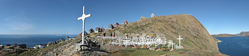
English: Panorama over Upernavik cemetery from the southern end of the island in North-West Greenland. At the time, the cemetery was in the process of being expanded, as it was running out of space. Thus, the construction work in the background. Individual photos taken with a Canon IXUS 800IS. Cylindrical projection. Foreground patched with frames taken two weeks later.
Français : Vue panoramique sur le cimetière d'Upernavik depuis l'extrémité sud de l'île, au nord-ouest du Groenland. Le chantier en arrière plan correspond à un travail d'agrandissement du cimetière.
Polski: Panorama cmentarza w Upernavik w północno-zachodniej części Grenlandii. Prace budowlane widoczne w tle miały na celu rozszerzenie cmentarza, na którym kończyło się miejsce. |
| Дата |
|
| Крыніца | Уласны твор |
| Аўтар | Photographed and stitched by Slaunger, edited by Paolo Costa |
| Іншыя вэрсіі |
Вытворныя творы ад гэтага файлу: Upernavik cemetary 2007-08-06 original stitch hd downsampled.jpg.jpg
|

| Месца камэры | | Гэтая й іншыя выявы на гэтым месцы: OpenStreetMap |
|---|

|
NOTE: This image is a panorama consisting of 11 frames that were merged or stitched in PTGui. As a result, this image necessarily underwent some form of digital manipulation. These manipulations may include blending, blurring, cloning, and colour and perspective adjustments. As a result of these adjustments, the image content may be slightly different from reality at the points where multiple images were combined. This manipulation is often required due to lens, perspective, and parallax distortions.
|
| Гэта рэтушаваная выява, якая была зьмененая ў лічбавай форме і адрозьніваецца ад арыгіналу. Зьмены: Extended stich with 5 individual photos taken from approximately the same location and time of day on 2007-08-20 by Slaunger. Crop, color banding, soft area, and seams edited by Paolo Costa..
|
Адзнакі
Гэтая выява зьяўляецца Выявай дня 6 жніўня 2016. Апісаньне: English: Upernavik cemetery from the southern end of the island in northwest Greenland on August 6, 2007. The construction work in the background was to expand the cemetery, which was running out of space. На іншых мовах:
Čeština: Hřbitov menšího města Upernavik na severozápadě Islandu. Hřbitov se v současné době rozšiřuje z důvodu nedostatku prostoru na původním místě. English: Upernavik cemetery from the southern end of the island in northwest Greenland on August 6, 2007. The construction work in the background was to expand the cemetery, which was running out of space. Polski: Panorama cmentarza w Upernavik w północno-zachodniej części Grenlandii. Prace budowlane widoczne w tle miały na celu rozszerzenie cmentarza, na którym kończyło się miejsce. |
|
Ліцэнзія
Я, уладальнік аўтарскіх правоў на гэтую працу, добраахвотна публікую яе на ўмовах наступнай ліцэнзіі:
Гэты файл ліцэнзаваны згодна ўмоваў ліцэнзіі Creative Commons Attribution 3.0 Unported.
- Вы можаце свабодна:
- дзяліцца – капіяваць, распаўсюджваць і перадаваць гэты твор
- ствараць вытворныя творы – адаптаваць твор
- Пры выкананьні наступных умоваў:
- пазначэньне аўтарства – Вы мусіце пазначыць аўтарства, падаць спасылку на ліцэнзію і пазначыць, ці былі зробленыя зьмены. Вы можаце зрабіць гэта любым разумным спосабам, але не такім чынам, каб склалася ўражаньне, што ліцэнзіят падтрымлівае вас ці выкарыстаньне вамі гэтага твору.
| Зацемкі | Гэтая выява мае дадатковыя зацемкі: праглядзець у Вікісховішчы |


Гісторыя файла
Націсьніце на дату/час, каб паглядзець, як тады выглядаў файл.
| Дата і час | Мініятура | Памеры | Удзельнік | Камэнтар | |
|---|---|---|---|---|---|
| цяперашняя | 01:14, 15 сьнежня 2011 | 12 485 × 2814 (17,01 Мб) | Paolostefano1412 | Sharpness, cloning, crop, stitch errors fixes... | |
| 23:17, 7 сьнежня 2011 | 14 103 × 3553 (18,2 Мб) | Slaunger | {{Information |Description={{en|Panorama over Upernavik cemetery from the southern end of the island in North-West Greenland. At the time, the cemetery was in the process of being expanded, as it was running out of spac |
Выкарыстаньне файла
Наступная старонка выкарыстоўвае гэты файл:
Глябальнае выкарыстаньне файла
Гэты файл выкарыстоўваецца ў наступных вікі:
- Выкарыстаньне ў ar.wikipedia.org
- Выкарыстаньне ў crh.wikipedia.org
- Выкарыстаньне ў cs.wikipedia.org
- Выкарыстаньне ў cv.wikipedia.org
- Выкарыстаньне ў hu.wikipedia.org
- Выкарыстаньне ў ka.wikipedia.org
- Выкарыстаньне ў ko.wikipedia.org
- Выкарыстаньне ў lbe.wikipedia.org
- Выкарыстаньне ў mg.wikipedia.org
- Выкарыстаньне ў mk.wikipedia.org
- Выкарыстаньне ў os.wikipedia.org
- Выкарыстаньне ў pt.wikipedia.org
- Выкарыстаньне ў ru.wikipedia.org
- Выкарыстаньне ў ru.wikinews.org
- Выкарыстаньне ў sah.wikipedia.org
- Выкарыстаньне ў sq.wikipedia.org
- Выкарыстаньне ў sr.wikipedia.org
- Выкарыстаньне ў tt.wikipedia.org
- Выкарыстаньне ў uk.wikipedia.org
- Выкарыстаньне ў zh.wikipedia.org