
Файл:Tannenberg3008.jpg
Памер прагляду: 775 × 600 піксэлаў. Іншыя разрозьненьні: 310 × 240 піксэлаў | 620 × 480 піксэлаў | 993 × 768 піксэлаў | 1242 × 961 піксэлаў.
Арыгінальны файл (1242 × 961 піксэль, памер файла: 207 кб, тып MIME: image/jpeg)
|
|
Гэты файл паходзіць зь Вікісховішча. Зьвесткі пра гэты файл зь яго старонкі апісаньня прыведзеныя ніжэй. Вікісховішча — сховішча вольных мэдыяфайлаў. Вы можаце дапамагчы. |

|
Існуе вэктарная вэрсія гэтай выявы (SVG). Рэкамэндуецца выкарыстаньне вэктарнай выявы замест растэрнай.
File:Tannenberg3008.jpg → File:East Prussian Campaign (27—30 Aug 1914) - ru.svg
Болей інфармацыі пра вэктарную графіку чытайце ў дапамозе. |
_-_ru.svg) |
| Апісаньне |
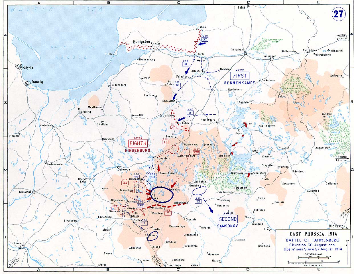
English: Battle of Tannenberg (1914) in its last phase |
| Крыніца |
Taken from the campaign series, made public by the US-Army under dean.usma.edu
|
| Аўтар | US-Army under www.dean.usma.edu |
| Дазвол (Паўторнае выкарыстаньне гэтага файлу) |
The picture is public domain. |
This file is a work of a U.S. Army soldier or employee, taken or made as part of that person's official duties. As a work of the U.S. federal government, it is in the public domain in the United States.
|
 |
Гісторыя файла
Націсьніце на дату/час, каб паглядзець, як тады выглядаў файл.
| Дата і час | Мініятура | Памеры | Удзельнік | Камэнтар | |
|---|---|---|---|---|---|
| цяперашняя | 17:29, 22 верасьня 2005 | | 1242 × 961 (207 кб) | Nasiruddin | Taken from the campaign series, made public by the US-Army under www.dean.usma.edu The öpicture is public domain. It shows the battle of Tannenberg in its last phase {{PD-USGov-Military-Army}} Category:World War I maps |
Выкарыстаньне файла
Наступная старонка выкарыстоўвае гэты файл:
Глябальнае выкарыстаньне файла
Гэты файл выкарыстоўваецца ў наступных вікі:
- Выкарыстаньне ў be.wikipedia.org
- Выкарыстаньне ў ca.wikipedia.org
- Выкарыстаньне ў cs.wikipedia.org
- Выкарыстаньне ў da.wikipedia.org
- Выкарыстаньне ў de.wikipedia.org
- Выкарыстаньне ў el.wikipedia.org
- Выкарыстаньне ў en.wikipedia.org
- Выкарыстаньне ў et.wikipedia.org
- Выкарыстаньне ў fi.wikipedia.org
- Выкарыстаньне ў fr.wikipedia.org
- Выкарыстаньне ў he.wikipedia.org
- Выкарыстаньне ў hr.wikipedia.org
- Выкарыстаньне ў it.wikipedia.org
- Выкарыстаньне ў ja.wikipedia.org
- Выкарыстаньне ў ko.wikipedia.org
- Выкарыстаньне ў lv.wikipedia.org
- Выкарыстаньне ў nl.wikipedia.org
- Выкарыстаньне ў no.wikipedia.org
- Выкарыстаньне ў pl.wikipedia.org
- Выкарыстаньне ў sv.wikipedia.org
- Выкарыстаньне ў uk.wikipedia.org
- Выкарыстаньне ў vi.wikipedia.org
- Выкарыстаньне ў zh.wikipedia.org