
Файл:Port Phillip Bay.png
Няма вэрсіі зь лепшым разрозьненьнем.
Port_Phillip_Bay.png (768 × 523 піксэлі, памер файла: 897 кб, тып MIME: image/png)
|
|
Гэты файл паходзіць зь Вікісховішча. Зьвесткі пра гэты файл зь яго старонкі апісаньня прыведзеныя ніжэй. Вікісховішча — сховішча вольных мэдыяфайлаў. Вы можаце дапамагчы. |
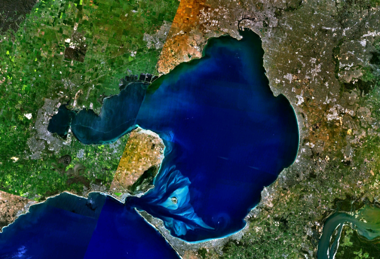
w:Port Phillip Bay, Australia. Melbourne is visible at the head of the bay, Geelong at the head of the western arm, Corio Bay.
| This image is in the public domain because it is a screenshot from NASA’s globe software World Wind using a public domain layer, such as Blue Marble, MODIS, Landsat, SRTM, USGS or GLOBE.
|
 |
Гісторыя файла
Націсьніце на дату/час, каб паглядзець, як тады выглядаў файл.
| Дата і час | Мініятура | Памеры | Удзельнік | Камэнтар | |
|---|---|---|---|---|---|
| цяперашняя | 00:56, 29 сьнежня 2005 | | 768 × 523 (897 кб) | Stephen Bain | w:Port Phillip Bay, Australia. Melbourne is visible at the head of the bay, Geelong at the head of the western arm, Corio Bay. {{PD-WorldWind}} |
Выкарыстаньне файла
Наступная старонка выкарыстоўвае гэты файл:
Глябальнае выкарыстаньне файла
Гэты файл выкарыстоўваецца ў наступных вікі:
- Выкарыстаньне ў ar.wikipedia.org
- Выкарыстаньне ў be.wikipedia.org
- Выкарыстаньне ў ceb.wikipedia.org
- Выкарыстаньне ў en.wikipedia.org
- Выкарыстаньне ў en.wikivoyage.org
- Выкарыстаньне ў es.wikipedia.org
- Выкарыстаньне ў fi.wikipedia.org
- Выкарыстаньне ў fr.wikipedia.org
- Выкарыстаньне ў ga.wikipedia.org
- Выкарыстаньне ў gl.wikipedia.org
- Выкарыстаньне ў he.wikipedia.org
- Выкарыстаньне ў he.wikivoyage.org
- Выкарыстаньне ў it.wikipedia.org
- Выкарыстаньне ў it.wiktionary.org
- Выкарыстаньне ў ja.wikipedia.org
- Выкарыстаньне ў lt.wikipedia.org
- Выкарыстаньне ў pl.wikipedia.org
- Выкарыстаньне ў pt.wikipedia.org
- Выкарыстаньне ў ru.wikipedia.org
- Выкарыстаньне ў simple.wikipedia.org
- Выкарыстаньне ў sv.wikipedia.org
- Выкарыстаньне ў uk.wikipedia.org
- Выкарыстаньне ў www.wikidata.org