
Файл:Fukushima I NPP 1975 medium crop rotated labeled.jpg

Памер прагляду: 300 × 600 піксэлаў. Іншыя разрозьненьні: 120 × 240 піксэлаў | 240 × 480 піксэлаў.
Арыгінальны файл (800 × 1600 піксэляў, памер файла: 248 кб, тып MIME: image/jpeg)
|
|
Гэты файл паходзіць зь Вікісховішча. Зьвесткі пра гэты файл зь яго старонкі апісаньня прыведзеныя ніжэй. Вікісховішча — сховішча вольных мэдыяфайлаў. Вы можаце дапамагчы. |
Апісаньне
| Апісаньне |
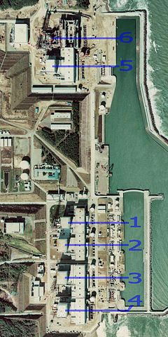
English: Fukushima I Nuclear Power Plant. Medium crop showing reactors labeled 1 to 5 and site for reactor 6. North is up.
日本語: 福島第一原子力発電所。 |
| Дата | |
| Крыніца | http://w3land.mlit.go.jp/cgi-bin/WebGIS2/WC_AirPhoto.cgi?IT=p&DT=n&PFN=CTO-75-30&PCN=C29B&IDX=21 |
| Аўтар | Ministry of Land, Infrastructure, Transport and Tourism |
| Іншыя вэрсіі |
|
| Месца камэры | | Гэтая й іншыя выявы на гэтым месцы: OpenStreetMap |
|---|
Ліцэнзія

|
Уладальнік аўтарскіх правоў на гэты файл, the Ministry of Land, Infrastructure, Transport and Tourism of Japan, дазваляе ўсім выкарыстоўваць яго ў любых мэтах, пры ўмове, што уладальнік аўтарскіх правоў пазначаны належным чынам. Распаўсюджаньне, стварэньне вытворных прац, камэрцыйнай выкарыстаньне і іншыя выкарыстаньні дазволеныя. |
Пазначэньне аўтарства:
Copyright © National Land Image Information (Color Aerial Photographs), Ministry of Land, Infrastructure, Transport and Tourism
|
 |
This image is copyrighted by the Ministry of Land, Infrastructure, Transport and Tourism of Japan. For terms of use, see the stipulation to use of National Land Information (in Japanese) and message from MLIT (in Japanese and English). When you display this image on an article, include the following phrase in the description: "Made based on National Land Image Information (Color Aerial Photographs), Ministry of Land, Infrastructure, Transport and Tourism".
|
Гісторыя файла
Націсьніце на дату/час, каб паглядзець, як тады выглядаў файл.
| Дата і час | Мініятура | Памеры | Удзельнік | Камэнтар | |
|---|---|---|---|---|---|
| цяперашняя | 02:54, 16 сакавіка 2011 | | 800 × 1600 (248 кб) | 84user | =={{int:filedesc}}== {{Information |Description={{en|1=Fukushima I Nuclear Power Plant. Medium crop showing reactors labeled 1 to 5 and site for reactor 6. North is up.}} {{ja|1=[[:ja:福島第一原子力発電所| |
Выкарыстаньне файла
Наступная старонка выкарыстоўвае гэты файл:
Глябальнае выкарыстаньне файла
Гэты файл выкарыстоўваецца ў наступных вікі:
- Выкарыстаньне ў ar.wikipedia.org
- Выкарыстаньне ў ast.wikipedia.org
- Выкарыстаньне ў ca.wikipedia.org
- Выкарыстаньне ў cs.wikipedia.org
- Выкарыстаньне ў cv.wikipedia.org
- Выкарыстаньне ў de.wikipedia.org
- Выкарыстаньне ў de.wikinews.org
- Выкарыстаньне ў en.wikipedia.org
- Выкарыстаньне ў en.wikibooks.org
- Выкарыстаньне ў es.wikipedia.org
- Выкарыстаньне ў fi.wikipedia.org
- Выкарыстаньне ў fr.wikipedia.org
- Выкарыстаньне ў gl.wikipedia.org
- Выкарыстаньне ў he.wikipedia.org
- Выкарыстаньне ў hi.wikipedia.org
- Выкарыстаньне ў ja.wikipedia.org
- Выкарыстаньне ў ko.wikipedia.org
- Выкарыстаньне ў ko.wikinews.org
- Выкарыстаньне ў ms.wikipedia.org
- Выкарыстаньне ў nl.wikipedia.org
- Выкарыстаньне ў pl.wikipedia.org
- Выкарыстаньне ў pt.wikipedia.org
- Выкарыстаньне ў rm.wikipedia.org
- Выкарыстаньне ў ru.wikipedia.org
- Выкарыстаньне ў sq.wikinews.org
- Выкарыстаньне ў ta.wikipedia.org
- Выкарыстаньне ў th.wikipedia.org
- Выкарыстаньне ў zh.wikipedia.org